|
|
ARES is a spatial association rule discovery system.
Theproblem solved by ARES can be formally stated asfollows:
Given
a spatial database (SDB),
a set of reference objects S,
some sets Rk, 1 <= k <= m, of task-relevant objects
a background knowledge BK including some spatial hierarchies Hk on objects in Rk
M granularity levels in the descriptions (1 is the highest while M is the lowest)
a couple of thresholds minsup[l] and minconf[l ] for each granularity level
Find strong multi-level spatial association rules.
Reference objects are the main subject of the description, while task-relevant objects are spatial objects that are relevant for the task in hand and are spatially related to the former. For instance, we may be interested in lookingfor spatial association rules that relate properties of some large towns (reference objects) with properties of other spatial objects, such as waterbodies and motorways (task-relevant objects). Each Rk is typically a map layer and spatial hierarchies capture is-a relations among locations on the basis of their geometry. To deal with several spatial hierarchies at once in a uniform manner, objects in them are mapped to one or more of the M user-defined description granularity levels so that frequency of patterns as well as strength of rules depend on the level l of granularity with which patterns/rules describe data. More precisely, a pattern P (s%) at level l is frequent if s>= minsup [l] and all ancestors of P with respectto Hk are frequent at their corresponding levels. An association rule Q -> R (s%, c%) at level l is strong if the pattern Q --> R (s%) is frequent and c>= minconf[l].
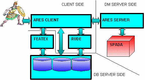
ARES' architecture is three-tiered:
FEATEX: an Oracle package that is capable to extract feature from map (map FEATure Extraction). It must be installed on a database server
Spada_EXE + ARES_Server: the implementation of SPADA algorithm, invokable remotely through the client. It must be installed on a data mining server
ARES_Client + Rude: The GUI is a client graphical interface that guides the user to compose visually the input files for Spada and uses RUDE algorithm to discretize contextually continuous attributes into categorical ones.
The problem is to caracterize the
highway Stockport's ED that are crossedby the highway.
There are 3
experiments, with different types of inputs:
Conjunctive
Constraint
Input
files for ARES
Output
files for ARES
No
Constraint
Input
files for ARES
Output
files for ARES
No Pure Spatial
Patterns
Input
File for training
Output
File of training
See the following reference
for further details on this problem:
D. Malerba, F. Esposito,
F.A. Lisi & A. Appice (2002). Mining spatial association rules
in census data, Research in Official Statistics, 5, 1, 19-44.
The problem is to determine the accessibility of Stepping Hill's hospital.
Input
File for training
Output
File of training
See the following reference for further details on this
problem:
A. Appice, M. Ceci, A. Lanza, F.A. Lisi, & D.
Malerba (2003). Discovery of Spatial Association Rules in
Georeferenced Census Data: A Relational Mining Approach, Intelligent
Data Analysis, 7,(in press).
D. Malerba, F.A. Lisi, A.
Appice & F. Sblendorio (2003). Mining Census and Geographic Data
in Urban Planning Environments. In L. Santini& D. Zotta (Eds.),
Terza Conferenza Nazionale su Informatica e Pianificazione Urbana e
Territoriale, Alinea Editrice, Florence, Italy.
There are five distribution packages:
Featex. The Featex component (Map Feature Extraction package, to be registered within Oracle)
Spada EXE. The implementation of SPADA algorithm
ARES Server. The server-side component that recalls SPADA Algorithm
ARES Client. The client-side component.
Autoclass library (DLL). A library that performs autoclass clustering algorithm, needed by RUDE, the discretization component.
First of all, download “Featex” zipfile: it contains three files:
Featex.txt (package interface)
Featex_Body.txt (package body)
Create_Table.txt (SQL
script)
To
install the package follow the following steps:
Open Oracle DBA Studio;
Connect to a database (e.g., the database of Stockport Maps);
Open Schema;
Open Package;
Create new empty package and name it FEATEX;
Copy Featex.txt into FEATEX;
Open Package Body;
Create new empty package body and name it FEATEX;
Copy Featex_body.txt in FEATEX package body;
Open SQL Plus;
Connect to the database (e.g., Stockport Maps);
Execute line command:
@ <directory>\ Create_Table.sql
to create the tables
necessary to execute the RELATE function;
Execute commit command;
Add
the parameter:
UTL_FILE_DIR = <dir_name>
to the
init.ora file in
order to specify a directory where the file output by the GENERATE
function is stored. The jolly character “*” is used for
a generic directory.
Restart the Oracle Server to make changes operational.
Download “Spada EXE” and “ARES Server” on the server machine, then unzip “Spada EXE”, putting the content ofthe zip file into “ C:\SPADA” folder on the server machine (this path is hard-coded). Then, it is possible to launch:
java -jar AresServer.jar [port-number]
on the server machine. Notice: the server machine must have a Windows [95/98/ME/NT/2000/XP] as OS.
Download “Autoclass DLL” on the client machine and copy the DLL into the SYSTEM folder of your Windows system
(\WINDOWS\SYSTEM for Win95,98,ME \WINNT\SYSTEM32 for WinNT,2000, \WINDOWS\SYSTEM32 for WinXP).
Note. If you have a Linux machine as a client, do not use Autoclass as clustering algorithm. You
can use only EM as clustering algorithm.
Finally, download “ARES Client” on the client machine, and launch:
java -jar AresClient.jar
The client will ask you for connection parameters (dependent from database); a click on “RUN ARES” will make the application start.
Warning: The system ARES is free for evaluation, research
and teaching purposes, but not for commercial purposes.
Please
Acknowledge
D. Malerba, F. Esposito, F.A. Lisi & A. Appice (2002). Mining spatial association rules in census data, Research in Official Statistics, 5, 1, 19-44.
A. Appice, M. Ceci, A. Lanza, F.A. Lisi, & D. Malerba (2003). Discovery of Spatial Association Rules in Georeferenced Census Data: A Relational Mining Approach, Intelligent Data Analysis, 7, 6.
D. Malerba, F.A. Lisi, A. Appice & F. Sblendorio (2003). Mining Census and Geographic Data in Urban Planning Environments. In L. Santini& D. Zotta (Eds.), Terza Conferenza Nazionale su Informatica e Pianificazione Urbana e Territoriale, Alinea Editrice, Firenze, Italia.
M. Ceci, A. Appice, & D. Malerba (2004). Spatial Associative Classification at Different Levels of Granularity: A Probabilistic Approach, in J.-F. Boulicaut, F. Esposito, F. Giannotti, & D. Pedreschi (Eds.), Knowledge Discovery in Databases: PKDD 2004, Lecture Notes in Artificial Intelligence, 3202, 99-111, Springer, Berlin, Germany.